New Plymouth weather changes fast. One moment the sun lights up the waterfront; the next, clouds roll in from the Tasman and a cool shower follows. This guide explains why the city’s weather behaves that way, gives practical examples, compares forecast sources, and shows how to choose the right information for beach days, gardening or mountain trips.
What is new plymouth weather?
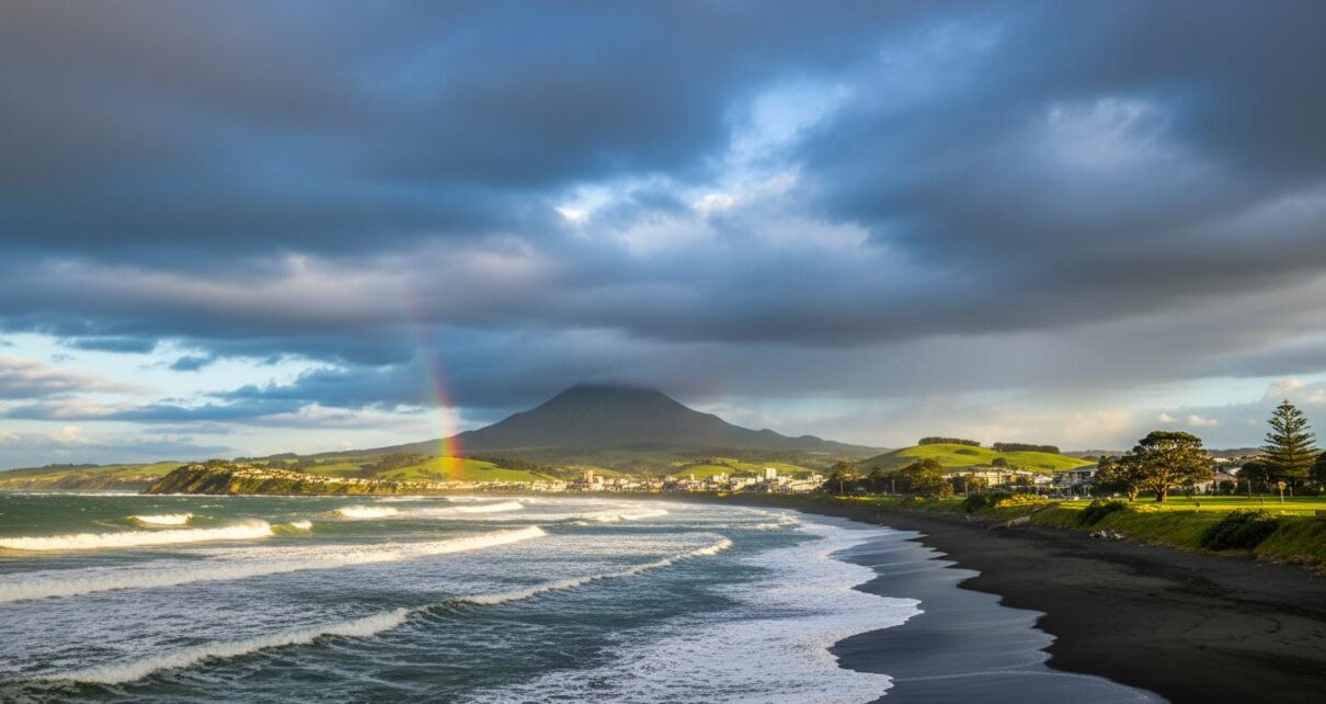
New Plymouth weather is best described as temperate and maritime. The city sits on the west coast of New Zealand’s North Island, so the ocean and the nearby cone of Mt Taranaki shape daily conditions.
- Quick answer: expect mild temperatures year-round, regular rain driven by westerly systems, and changeable skies.
- Typical pattern: warm-ish summers, cool but not severely cold winters, and frequent wind or rainbands from the Tasman Sea.
- Local effect: Mt Taranaki produces orographic rain on its slopes and influences wind and cloud patterns close to the mountain.
How it works
Several simple forces combine to produce New Plymouth weather. Understanding them helps you read forecasts and know what matters.
Ocean and maritime influence
The Tasman Sea moderates temperature swings. Sea breezes cool summer afternoons and keep winter nights milder than inland areas.
Prevailing winds and fronts
Westerly winds and passing frontal systems are common. When a cold front moves in from the Tasman, expect falling temperatures, cloud, and rain. Between fronts, high pressure brings clearer skies and lighter winds.
Mount Taranaki’s role
The mountain forces air to rise, which cools and forms clouds. That creates heavier rain on the western and southern slopes and can produce local showers even when coastal areas seem settled.
Sea conditions and swell
Large swells can arrive from the southwest or west, affecting surf and coastal erosion. Swell size and direction matter more for surfers, lifeguards and harbour users than air temperature does.
Types / examples
Here are typical weather scenarios you’ll see in New Plymouth, and what they mean for your plans.
- Summer beach day: Morning sun, sea breeze from late morning, afternoon cloud building — pack sunscreen and a light windbreaker.
- Changeable spring day: Rapid shifts between sunshine and showers; layers are essential.
- Winter westerly change: Rain bands with gusty winds; rivers and gullies can rise quickly.
- Calm high-pressure spell: Clear nights, possible morning fog near the estuary.
- Mountain conditions: Cold, wet and windy above the bushline — weather can be much harsher on Mt Taranaki than on the coast.
Forecast types you’ll use
- Short-term: radar, nowcasts and hourly forecasts for the next 0–24 hours.
- Medium-range: 3–7 day model guidance and synoptic charts.
- Long-range and outlooks: seasonal outlooks and climate summaries (useful for planting or travel planning).
- Warnings and watches: official alerts for heavy rain, gales, or surf hazards.
Pros and cons
Living with New Plymouth weather has clear upsides and downsides. Knowing both helps you plan better.
Pros
- Mild temperatures year-round — you rarely face extremes of heat or cold.
- Green landscapes and reliable rainfall for gardens and dairy farming.
- Great surf breaks and attractive coastal scenery.
Cons
- Changeable conditions can spoil outdoor plans at short notice.
- Persistent west or southwest rain can cause localized flooding and slippery roads.
- Windy days can make coastal activities less pleasant and affect events on the foreshore.
How to use or choose
Follow this simple routine to pick the right forecast and act on it.
- Decide your time horizon: immediate (hours), short (1–3 days) or longer (weekly).
- Choose the right source (see table below): official warnings for hazards, radar for imminent rain, model output for planning.
- Check local webcams, harbour cameras and recent radar loops to confirm conditions on the ground.
- Plan with margins: bring layers, waterproofs and allow extra travel time during wet/windy forecasts.
- For mountain trips, check alpine-specific forecasts and avalanche or route notes; postpone if conditions are uncertain.
Practical packing checklist for New Plymouth outings:
- Light waterproof jacket
- Sun protection (hat, sunscreen)
- Windproof layer
- Footwear suitable for wet ground
- Phone with local weather and Civil Defence apps
Comparison table: forecast sources for new plymouth weather
| Source | Best for | Strengths | Limitations |
|---|---|---|---|
| MetService | Official forecasts and warnings | Authoritative alerts, radar, hourly forecasts | Less interpretive commentary |
| NIWA | Climate outlooks and research | Long-range outlooks, climate data and rainfall summaries | Not for minute-by-minute decisions |
| WeatherWatch NZ | Local commentary and context | Accessible analysis, regional insights | Opinionated—use alongside official sources |
| MetVUW (model outputs) | Model maps and technical users | Detailed model guidance, multiple variables | Requires interpretation; can differ from official forecasts |
| Local webcams & surf reports | Real-time on-the-ground view | Immediate visual confirmation | Limited geographic coverage |
FAQ
How warm does New Plymouth get?
Summers are generally warm but rarely extreme. Daytime highs often reach the high teens to low twenties Celsius on typical summer days. Evenings cool off due to sea breezes.
Does it rain a lot in New Plymouth?
Rain is fairly frequent. Westerly systems from the Tasman bring bands of rain. You should expect showers through much of the year, with heavier and more persistent falls during active weather periods.
When is the best time for beaches and surf?
Late summer offers the warmest sea temperatures and more settled weather. Surf lovers watch swell forecasts—good waves can arrive year-round, but conditions depend on swell direction and wind.
Is New Plymouth windy?
Yes. The city sees westerly and south-westerly winds often. Nor’west winds can also occur and feel warmer. Wind strength varies with each frontal change.
How changeable is spring weather?
Spring is famously changeable. Warm sunny spells can be interrupted by cold fronts and showers. Layered clothing is the practical choice in spring.
Where do I get official alerts for severe weather or tsunamis?
For weather warnings use MetService. For civil defence and tsunami warnings check MCDEM (Ministry of Civil Defence & Emergency Management) and the NZ Civil Defence app. GeoNet provides geological hazard updates such as earthquakes and tsunami-related advisories.
Do I need a special forecast for Mt Taranaki?
Yes. Mountain weather is harsher and more unpredictable than the coast. Use alpine-specific forecasts and local DOC (Department of Conservation) advice before any climb.
Final notes
New Plymouth weather rewards a flexible approach. Keep an eye on short-term radar for imminent showers, consult MetService for official warnings, and use local sources and webcams for context. With the right planning—layers, a rain jacket, and a quick check of the forecast—you’ll enjoy the coast, the mountain and the many outdoor events the region offers.